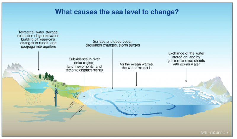
Increasing temperatures due to climate change raise concerns regarding sea level rise in coastal areas. Sea level rise has caused an increase in tidal floods associated with nuisance-level impacts. Nuisance floods are events in which water levels exceed the local threshold for minor impacts. These events can damage infrastructure, cause road closures, and overwhelm storm drains. As sea level has risen along the Georgia coastline, the number of tidal flood days (all days exceeding the nuisance level threshold) has also increased, with the greatest number occurring in 2013 and 2015. Georgia is at extreme risk for sea level rise due to its low elevation along the coast. Continued sea level rise will present major challenges to Georgia’s existing coastal water management system and could cause extensive economic damage through ecosystem damage and losses in property, tourism, and agriculture.
Publications
| Title | Description | Year |
|---|---|---|
| Projections of multiple climate-related coastal hazards for the US Southeast Atlantic | Faced with accelerating sea level rise and changing ocean storm conditions, coastal communities require comprehensive assessments of climate-driven hazard impacts to inform adaptation measures. Previous studies have focused on flooding but rarely on other climate-related coastal hazards, such as subsidence, beach erosion and groundwater. Here, we project societal exposure to multiple hazards along the Southeast Atlantic coast of the United States. Assuming 1 m of sea level rise, more than 70% of the coastal residents and US$1 trillion in property are in areas projected to experience shallow and emerging groundwater, 15 times higher than daily flooding. Storms increase flooding exposure by an order of magnitude over daily flooding, which could impact up to ~50% of all coastal residents and US$770 billion in property value. The loss of up to ~80% of present-day beaches and high subsidence rates that currently affect over 1 million residents will exacerbate flooding and groundwater hazard risks. | 2025 |
| Disappearing cities on US coasts | The sea level along the US coastlines is projected to rise by 0.25–0.3 m by 2050, increasing the probability of more destructive flooding and inundation in major cities1,2,3. However, these impacts may be exacerbated by coastal subsidence—the sinking of coastal land areas4—a factor that is often underrepresented in coastal-management policies and long-term urban planning2,5. In this study, we combine high-resolution vertical land motion (that is, raising or lowering of land) and elevation datasets with projections of sea-level rise to quantify the potential inundated areas in 32 major US coastal cities. Here we show that, even when considering the current coastal-defence structures, further land area of between 1,006 and 1,389 km2 is threatened by relative sea-level rise by 2050, posing a threat to a population of 55,000–273,000 people and 31,000–171,000 properties. | 2024 |
| The projected exposure and response of a natural barrier island system to climate-driven coastal hazards | Accelerating sea level rise (SLR) and changing storm patterns will increasingly expose barrier islands to coastal hazards, including flooding, erosion, and rising groundwater tables. We assess the exposure of Cape Lookout National Seashore, a barrier island system in North Carolina (USA), to projected SLR and storm hazards over the twenty-first century. We estimate that with 0.5 m of SLR, 47% of current subaerial barrier island area would be flooded daily, and the 1-year return period storm would flood 74%. For 20-year return period storms, over 85% is projected to be flooded for any SLR. The modelled groundwater table is already shallow (< 2 m deep), and while projected to shoal to the land surface with SLR, marine flooding is projected to overtake areas with emergent groundwater. Projected shoreline retreat reaches an average of 178 m with 1 m of SLR and no interventions, which is over 60% of the current island width at narrower locations. Compounding these hazards is subsidence, with one-third of the study area currently lowering at > 2 mm/yr. | 2024 |
| Evaluating Knowledge Gaps in Sea-Level Rise Assessments From the United States | It is unknown if scientific advances are readily incorporated into local SLR assessments used by the public for decision making. To better understand where knowledge gaps exist in SLR assessments, we construct and analyze a database of the most recent local assessments for the United States (U.S.). We find differences in assessments among regions, including the time horizons used for future projections, and varying preferences for single values of SLR versus ranges that better capture uncertainty. Over half of U.S. communities included in our analysis underestimate the high end of future SLR compared to the Intergovernmental Panel on Climate Change Sixth Assessment Report. | 2023 |
| 2022 Sea Level Rise Technical Report | This multi-agency effort, representing the first update since 2017, offers projections out to the year 2150 and information to help communities assess potential changes in average tide heights and height-specific threshold frequencies as they strive to adapt to sea level rise. The report states that sea level along the U.S. coastline is projected to rise, on average, 10 - 12 inches in the next 30 years (2020 - 2050), which will be as much as the rise measured over the last 100 years (1920 - 2020). Sea level rise will vary regionally along U.S. coasts because of changes in both land and ocean height. | 2022 |
| Inequitable patterns of US flood risk in the Anthropocene | Current flood risk mapping, relying on historical observations, fails to account for increasing threat under climate change. Incorporating recent developments in inundation modelling, here we show a 26.4% increase in US flood risk by 2050 due to climate change alone. Our national depiction of comprehensive and high-resolution flood risk estimates in the US indicates current average annual losses of $32.1 billion in 2020’s climate, which are borne disproportionately by poorer communities with a proportionally larger White population. The future increase in risk will disproportionately impact Black communities, while remaining concentrated on the Atlantic and Gulf coasts. Furthermore, projected population change could cause flood risk increases that outweigh the impact of climate change fourfold. These results make clear the need for adaptation to flood and emergent climate risks in the US, with mitigation required to prevent the acceleration of these risks. | 2022 |
| Chapter 9 of the IPCC Physical Science Basis for Climate Change: Ocean, Cryosphere, and Sea Level Change | This chapter assesses past and projected changes in the ocean, cryosphere and sea level using paleo-reconstructions, instrumental observations and model simulations. In the following summary, we update and expand the related assessments from the IPCC Fifth Assessment Report (AR5), the Special Report on Global Warming of 1.5oC (SR1.5) and the Special Report on Ocean and Cryosphere in a Changing Climate (SROCC). Major advances in this chapter since the SROCC include the synthesis of extended and new observations, which allows for improved assessment of past change, processes and budgets for the last century, and the use of a hierarchy of models and emulators, which provide improved projections and uncertainty estimates of future change. In addition, the systematic use of model emulators makes our projections of ocean heat content, land-ice loss and sea level rise fully consistent both with each other and with the assessed equilibrium climate sensitivity and projections of global surface air temperature across the entire report. | 2021 |
| Modeling migration patterns in the USA under sea level rise | Sea level rise in the United States will lead to large scale migration in the future. We propose a framework to examine future climate migration patterns using models of human migration. Our framework requires that we distinguish between historical versus climate driven migration and recognizes how the impacts of climate change can extend beyond the affected area. We apply our framework to simulate how migration, driven by sea level rise, differs from baseline migration patterns. The results of our case study suggest that the effects of sea level rise are pervasive, expanding beyond coastal areas via increased migration, and disproportionately affecting some areas of the United States. | 2020 |
| HIGH TIDE TAX: The Price to Protect Coastal Communities from Rising Seas | This study provides the first estimate for the contiguous U.S. of the costs associated with armoring coastal areas that contain public infrastructure and that are projected to be flooded by sea-level rise. The primary focus of this study is estimating the costs of ensuring that roads, rails, and other public infrastructure are protected from the predicted near-term and long-term impacts of sea-level rise under moderate, not worst case, emissions scenarios. | 2019 |
| Coastal dynamics and adaptation to uncertain sea level rise: Optimal portfolios for salt marsh migration | Marsh sustainability under rapid sea level rise requires the preservation of transgression zones - undeveloped uplands onto which marshes migrate. This paper develops the first adaptation portfolio model designed to optimize the benefits of a migrating coastal system. Results are illustrated using a case study of marsh conservation in Virginia, USA. Results suggest that models of this type can enhance adaptation benefits beyond those available through current approaches. | 2019 |
| Ocean at the Door: New Homes and the Rising Sea | In 2018, Climate Central and Zillow produced the first nationwide analysis of the number of new homes in areas vulnerable to coastal flooding in all 24 coastal states and the District of Columbia. This research projected how many homes will become exposed to on-average annual ocean flooding in the coming decades—depending on what choices the world makes around greenhouse-gas pollution today. This report improves those results by incorporating full home footprint data instead of point location estimates, and also provides results for bigger floods, in addition to annual ones. | 2019 |
| Assessing coastal wetland vulnerability to sea-level rise along the northern Gulf of Mexico coast: Gaps and opportunities for developing a coordinated regional sampling network | In this study, we quantify the distribution of surface elevation table-marker horizon (SET-MH) stations along the northern Gulf of Mexico coast across states, wetland habitats, and ecologically-relevant abiotic gradients (i.e., gradients in temperature, precipitation, elevation, and relative sea-level rise). Our analyses identify areas with high SET-MH station densities as well as areas with notable gaps. Salt marshes, intermediate elevations, and colder areas with high rainfall have a high number of stations, while salt flat ecosystems, certain elevation zones, the mangrove-marsh ecotone, and hypersaline coastal areas with low rainfall have fewer stations. Our findings represent the first attempt to examine spatial gaps in SET-MH coverage across abiotic gradients. Our analyses can be used to transform a broadly disseminated and unplanned collection of SET-MH stations into a coordinated and strategic regional network. | 2017 |
| Climate Change and Homes: Who Would Lose the Most to a Rising Tide? | Building on its 2016 analysis of the impact a rising tide could have on U.S. homes, Zillow looked again at how many homes might be underwater by the end of the century — and whether those homes are in the top, middle or bottom tier in their areas. Zillow also calculated the share in urban, suburban and rural areas. Key findings include: • One-third (32%) of underwater homes would be valued in the bottom third nationally, meaning $123 billion in losses. • Two in five (39%) underwater homes would be valued in the top third nationally, translating to $597 billion in lost high-end real estate. • In rural and suburban areas, homes in the top value tier may face particular risk, while in urban areas homes in the bottom value tier are more likely to be affected. | 2017 |
| Climate Science Special Report: Fourth National Climate Assessment (NCA4), Volume I | This chapter reviews the physical factors driving changes in global mean sea level (GMSL) and those causing additional regional variations in relative sea level (RSL). It presents geological and instrumental observations of historical sea level changes and an assessment of the human contribution to sea level change. It then describes a range of scenarios for future levels and rates of sea level change, and the relationship of these scenarios to the Representative Concentration Pathways (RCPs). Finally, it assesses the impact of changes in sea level on extreme water levels. | 2017 |
| Sea level rise drives increased tidal flooding frequency at tide gauges along the U.S. East and Gulf Coasts: Projections for 2030 and 2045 | Tidal flooding is among the most tangible present-day effects of global sea level rise. Here, we utilize a set of NOAA tide gauges along the U.S. East and Gulf Coasts to evaluate the potential impact of future sea level rise on the frequency and severity of tidal flooding. Using the 2001–2015 time period as a baseline, we first determine how often tidal flooding currently occurs. Using localized sea level rise projections based on the Intermediate-Low, Intermediate-High, and Highest projections from the U.S. National Climate Assessment, we then determine the frequency and extent of such flooding at these locations for two near-term time horizons: 2030 and 2045. We show that increases in tidal flooding will be substantial and nearly universal at the 52 locations included in our analysis. Long before areas are permanently inundated, the steady creep of sea level rise will force many communities to grapple with chronic high tide flooding in the next 15 to 30 years. | 2017 |
| Impediments to inland resettlement under conditions of accelerated sea level rise | Recent research suggests that global mean sea level rise may endanger the low-elevation coastal zone sooner than expected, reshaping coastal geography, reducing habitable landmass, and seeding significant coastal out-migrations. Our research reviews the barriers to entry in the noncoastal hinterland. Using three organizing clusters (depletion zones, win-lose zones, and no-trespass zones), we identify principal inland impediments to relocation and provide preliminary estimates of their toll on inland resettlement space. We make the case for proactive adaptation strategies extending landward from on global coastlines and illustrate this position with land use planning responses in Florida and China. | 2017 |
| Temperature Decouples Ammonium and Nitrite Oxidation in Coastal Waters | Analysis of field data from 270 stations in 29 temperate and subtropical estuaries and lagoons show transient accumulation of nitrite driven primarily by water temperatures, rather than by hypoxia. Increased climate variability and warming coastal waters may therefore increase the frequency of these nitrite peaks, with potential ecosystem consequences that include increased N2O production, NO2– toxicity, and shifts in phytoplankton community composition. | 2017 |
| Wave Exposure Structures Oyster Distribution on Natural Intertidal Reefs, But Not on Hardened Shorelines | Although intertidal oyster reefs are valued for attenuating wave erosion, little attention has been paid to the effects of wave exposure on their distribution. The present study characterized the role of wave exposure in determining the distribution of natural intertidal oyster reefs and of oysters on hardened shorelines (bulkhead and riprap revetments). Wave exposure was determined using the National Oceanic and Atmospheric Administration (NOAA)-developed Wave Exposure Model (WEMo), which integrates adjacent water depth, fetch, and processed wind information, among other variables. Field mapping of oyster reefs in Pamlico and Core sounds, North Carolina, USA, was conducted in summer 2014. Wave exposure was not correlated with the presence of oysters on hardened shorelines. | 2017 |
| Centuries of thermal sea-level rise due to anthropogenic emissions of short-lived greenhouse gases | We show that short-lived greenhouse gases contribute to sea-level rise through thermal expansion (TSLR) over much longer time scales than their atmospheric lifetimes. Chlorofluorocarbons and hydrochlorofluorocarbons have already been phased out under the Montreal Protocol due to concerns about ozone depletion and provide an illustration of how emission reductions avoid multiple centuries of future TSLR. We examine the “world avoided” by the Montreal Protocol by showing that if these gases had instead been eliminated in 2050, additional TSLR of up to about 14 cm would be expected in the 21st century, with continuing contributions lasting more than 500 y. Sea-level rise is often assumed to follow air temperature, but this assumption holds only for TSLR when temperatures are increasing. We present a more complete formulation that is accurate even when atmospheric temperatures are stable or decreasing due to reductions in short-lived gases or net radiative forcing. | 2017 |
| An empirical analysis of cultural ecosystem values in coastal landscapes | This study describes and analyzes the distribution of cultural ecosystem values found in coastal areas in 5 countries and compares the results with non-coastal areas. Mapped cultural ecosystem values were collected from public participation GIS (PPGIS) processes in the U.S., Australia, New Zealand, Norway, and Malaysia and analyzed to identify the type and intensity of ecosystem values located in coastal areas. Mapped ecosystem values were significantly more abundant in all coastal zones, regardless of ecosystem value category, country, population, or dominant land use. Economic and social values were significantly associated with developed (built) coastal zones, while aesthetic and recreation values were more strongly associated with natural coastal zones. Understanding trade-offs in coastal zone planning and management requires a systematic inventory of the full range of ecosystem services, including cultural services. | 2017 |
| Migration induced by sea-level rise could reshape the US population landscape | With millions of potential future migrants in heavily populated coastal communities, SLR scholarship focusing solely on coastal communities characterizes SLR as primarily a coastal issue, obscuring the potential impacts in landlocked communities created by SLR-induced displacement. Here I address this issue by merging projected populations at risk of SLR with migration systems simulations to project future destinations of SLR migrants in the US. I find that unmitigated SLR is expected to reshape the US population distribution, potentially stressing landlocked areas unprepared to accommodate this wave of coastal migrants—even after accounting for potential adaptation. | 2017 |
| Coastal Floods: Sea Level Rise and the Human Fingerprint on U.S. Floods since 1950 | This analysis reviews the assessed human-caused component in global sea level from hourly water level records since 1950 at 27 U.S. tide gauges, creating alternative histories simulating the absence of anthropogenic climate change. Out of 8,726 days when unaltered water level observations exceeded National Weather Service local “nuisance” flood thresholds for minor impacts, 5,809 days did not exceed thresholds in the alternative histories. In other words, human-caused global sea level rise effectively tipped the balance, pushing high water events over the threshold, for about two-thirds of the observed flood days. The fraction has increased from less than half in the 1950s, to more than three-quarters within the last decade (2005-2014), as global sea level has continued to rise. | 2016 |
| Guide for Considering Climate Change in Coastal Conservation | This guide provides a step-by-step approach, with links to relevant tools, information, and other resources. The document focuses on climate considerations and tools specifically relevant to the coastal environment, including coastal watersheds. The six iterative steps draw on existing guidelines for conservation, as well as newer climate adaptation resources. The information is suitable for anyone working to manage or conserve lands in coastal areas, such as coastal planners, land or watershed conservation organizations, wetland and floodplain managers, emergency managers, and more. The approach provided in this guide can be used to create a new plan if one is needed, to update an existing plan, or to further other types of planning, such as hazard mitigation or comprehensive plans. | 2016 |
| Coastal sea level rise with warming above 2 °C | Here we provide probabilistic sea level rise projections for the global coastline with warming above the 2°C goal. By 2040, with a 2°C warming, more than 90% of coastal areas will experience sea level rise exceeding the global estimate of 0.2 m, with up to 0.4 m expected along the Atlantic coast of North America and Norway. With a 5°C rise by 2100, sea level will rise rapidly, reaching 0.9 m (median), and 80% of the coastline will exceed the global sea level rise at the 95th percentile upper limit of 1.8 m. The coastal communities of rapidly expanding cities in the developing world, and vulnerable tropical coastal ecosystems, will have a very limited time after midcentury to adapt to sea level rises. | 2016 |
| Enhanced Atlantic sea-level rise relative to the Pacific under high carbon emission rates | Here we present simulations using a numerical atmospheric-ocean general circulation model with an interactive carbon cycle to evaluate the impact of carbon emission rates on basin-scale ocean heat uptake and sea level. For simulations with emission rates greater than 5 GtC yr−1, sea-level rise is larger in the Atlantic than Pacific Ocean on centennial timescales. This basin-scale asymmetry is related to the shorter flushing timescales and weakening of the overturning circulation in the Atlantic. These factors lead to warmer Atlantic interior waters and greater thermal expansion. We conclude that Atlantic coastal areas may be particularly vulnerable to near-future sea-level rise from present-day high greenhouse gas emission rates. | 2016 |
| Assessing tidal marsh resilience to sea-level rise at broad geographic scales with multi-metric indices | Here, we develop and apply tidal marsh resilience to sea-level rise (MARS) indices incorporating ten metrics that contribute to overall marsh resilience to SLR. We applied MARS indices to tidal marshes at 16 National Estuarine Research Reserves across the conterminous U.S. This assessment revealed moderate resilience overall, although nearly all marshes had some indication of risk. Pacific marshes were generally more resilient to SLR than Atlantic ones, with the least resilient marshes found in southern New England. We provide a calculation tool to facilitate application of the MARS indices to additional marshes. | 2016 |
| EPA Climate Change Indicators in the United States (2016) | EPA partners with more than 40 data contributors from various government agencies, academic institutions, and other organizations to compile a key set of indicators related to the causes and effects of climate change. The indicators are published in EPA's report, Climate Change Indicators in the United States, available on this website and in print. The indicators include: Greenhouse Gases, Weather & Climate, Oceans, Snow & Ice, Health & Society, and Ecosystems. | 2016 |
| Carbon choices determine US cities committed to futures below sea level | Based on detailed topographic and population data, local high tide lines, and regional long-term sea-level commitment for different carbon emissions and ice sheet stability scenarios, we compute the current population living on endangered land at municipal, state, and national levels within the United States. For unabated climate change, we find that land that is home to more than 20 million people is implicated and is widely distributed among different states and coasts. The total area includes 1,185–1,825 municipalities where land that is home to more than half of the current population would be affected, among them at least 21 cities exceeding 100,000 residents. | 2015 |
| Spatial response of coastal marshes to increased atmospheric CO2 | Coastal marshes provide numerous ecosystem services, are an important carbon sink, and are exposed to drowning as sea-level rise accelerates. Using a meta-analysis of the available observational data, we model the coupled marsh vegetation and morphological dynamics. We find that the fertilization effect of elevated atmospheric CO2 significantly increases marsh resilience to drowning and decreases the spatial extent of marsh retreat under high rates of sea-level rise. While this direct CO2 fertilization effect has so far been neglected in marsh modeling, we find it is central in determining marsh survival under the foreseeable range of climatic changes. | 2015 |
Tools
| Title | Description |
|---|---|
| Interagency Sea Level Rise website | Created collaboratively by NOAA, NASA, FEMA, EPA, USACE, USGS, and DOD; contains Sea Level Rise 101 overview and new National Sea Level Explorer tool where you can look up info by region, state, or tide gauge. |
| NOAA Sea Level Rise Calculator | This is an in-depth tool for planners and practitioners, allowing you to view sea level rise scenarios and trends, changes in flood frequency, and extreme water levels. If you scroll down on the homepage, there are brief tutorials for different features under Quick Views. |
| U.S. Army Corps of Engineers Sea Level Analysis Tool (SLAT) | Technical tool that integrates the USACE Sea Level Change Curve Calculator and Sea Level Tracker; allows you to choose a sea level rise scenario and estimate when tidal or extreme water levels will intersect with elevation thresholds for local infrastructure. |
| NASA Flooding Analysis Tool | Allows you to choose a tide gauge, threshold, and scenario to see past and future flood frequency. |
| NOAA's Coastal County Snapshots | This online tool, with recently added data sets and functionality, provides an easy way to better understand county resilience in terms of flood hazards,critical facilities, and more. Users choose their county and topic of interest and the tool does the rest, automatically combining complex data sets to create county-specific insights. The resulting charts and graphics are easy to understand and are used to show community leaders and the public where the county is most vulnerable. |
| Climate Explorer | Explore climate projections for any county in the United States. For the contiguous U.S., you can compare maps of past and projected conditions for coming decades or consult historical records to see when weather has veered outside of normal climate. |
| Sea Level Rise Viewer | NOAA's Digital Ocean program has produced this web mapping tool that enables users tovisualize community-level impacts from coastal flooding or sea level rise (up to 10 feet above average high tides). Photo simulations of how future flooding might impact local landmarks are also provided, as well as data related to water depth, connectivity, flood frequency, socio-economic vulnerability, wetland loss and migration, and mapping confidence. |
| Tutorial for Sea Level Rise Viewer: Marsh Migration | Explore the impacts of sea level rise inundation on local wetlands using the marsh migration tab of NOAA’s Sea Level Rise Viewer. This self-guided tutorial uses an example to help you optimize the viewer and get the This tutorial provides the information natural resource managers, local government planners, and other stakeholders need to guide decisions about where to focus monitoring, restoration, and conservation efforts. |
| Should coastal planners have concern over where land ice is melting? | In this study, we exploit an advanced mathematical property of adjoint systems and determine the exact gradient of sea-level fingerprints with respect to local variations in the ice thickness of all of the world’s ice drainage systems. By mapping these fingerprint gradients, we form a new diagnosis tool, henceforth referred to as gradient fingerprint mapping (GFM), that allows for improved assessments of future coastal inundation or emergence. We demonstrate that for Antarctica and Greenland, changes in the predictions of inundation at major port cities depend on the location of the drainage system. For example, in New York, LSL change predictions are greatly sensitive to changes in the northeastern portions of the Greenland Ice Sheet. We apply GFM to 293 major port cities to allow coastal planners to readily calculate LSL change as more reliable predictions of cryospheric mass changes become available. |
| Surging Seas: Ocean at the Door | The Surging Seas: Ocean at the Door map shows the vulnerability of old and new housing stock to rising seas and chronic floods. Potential flood exposure maps are generated by comparing land elevation to the height of a typical once-a-year flood, plus local sea level rise projections over time. Areas below the resulting heights are classified as being in a “risk zone.” This map displays the number and value of homes located in the selected risk zone, including a special focus on recently built homes. The map incorporates the latest, high-resolution, high-accuracy lidar elevation data supplied by NOAA and provides the ability to search by location name or postal code. This map is paired with a companion report, brief, and interactive tool (scroll to the “Future Flood Risk to Homes” section of the tool after inputting a location name). |
| Coastal Flood Exposure Mapper | This tool allows users to explore local maps to stimulate discussions about the people, places, and natural resources exposed to coastal flooding. Users can also create a collection of maps showing risk from various hazards. |
Resources
| Title | Description | Year |
|---|---|---|
| $20B Needed to Shield South Carolina from Rising Sea Levels | In a state where rising sea levels are threatening oceanfront property, building $20 billion worth of seawalls would protect South Carolina’s coast from the effects of climate change during the next 20 years, a new study by the Center for Climate Integrity says. The $20 billion cost estimate was based on a 6-inch rise in sea level and a 21-inch storm surge. The report says South Carolina needs 3,202 miles of seawalls — enough to cover the entire coast — to shield its beaches, marshes and tidal rivers from sea-level rise. | 2020 |
| Where America's Climate Migrants Will Go As Sea Level Rises | 13 million U.S. coastal residents are expected to be displaced by 2100 due to sea level rise. Researchers are starting to predict where they’ll go. | 2020 |
| Florida Keys Deliver a Hard Message: As Seas Rise, Some Places Can’t Be Saved | Officials in the Florida Keys announced what many coastal governments nationwide have long feared, but few have been willing to admit: As seas rise and flooding gets worse, not everyone can be saved. And in some places, it doesn’t even make sense to try. | 2019 |
| 82 Days Underwater: The Tide Is High, but They’re Holding On | A brutal “king tides” season made worse by climate change has flooded the streets of a Florida Keys community for nearly three months. | 2019 |
| Amid flooding and rising sea levels, residents of one barrier island wonder if it’s time to retreat | Ocracoke Island, NC has been closed to visitors ever since Hurricane Dorian hit last September. And long-time residents are questioning whether and how long this barrier island can survive in the face of threats from extreme weather and rising sea levels. And if it can’t, why rebuild? | 2019 |
| Wild Weather and Climate Change: Scientists Are Unraveling the Links | One of the trickiest aspects of climate science is figuring out if a particular heat wave, flood, or drought was made more likely or severe by climate change. But researchers are getting far better at untangling the relationship between extreme weather and global warming. | 2017 |
| When Rising Seas Transform Risk into Certainty | Along parts of the East Coast, the entire system of insuring coastal property is beginning to break down. | 2017 |
| Georgia island confronts 'blue sky' floods | Sea-level rise poses daunting ecological and economic challenges to historic Sapelo Island. | 2017 |
| Westernmost, low-lying region of Louisiana coast on track to drown under sea level rise | Without major efforts to rebuild Louisiana's wetlands, which serve as bulwarks against waves and rising seas, the state's coast has little chance of withstanding the accelerating rate of sea level rise, a new study concludes. | 2017 |
| Atlantic City and Miami Beach: two takes on tackling the rising waters | Sea level rise is making floods more common and as the New Jersey resort braces for the next Sandy, the well-heeled Florida city is throwing money at the problem. | 2017 |
| Why the U.S. East Coast could be a major ‘hotspot’ for rising seas | “[N]ew research [by] scientists us[ing] a high powered climate change model . . . that simulates the ocean, the atmosphere and the cycling of carbon throughout the Earth system . . . found that at high emissions scenarios similar to current rates, the Atlantic sea levels rise considerably faster than the Pacific, with particularly noteworthy impacts for the U.S. East Coast. “The reason for the difference . . . water that sinks beneath the surface in the Atlantic will generally make it back to the surface again in 200 to 300 years, versus about three times as long for the Pacific . . . leading to warmer water pooling below the surface and, ultimately, greater warming overall. Warm water expands, and that’s the cause of the sea level rise expected in the study.” | 2016 |
| Abrupt Sea Level Rise Looms as Increasingly Realistic Threat | Ninety-nine percent of the planet's freshwater ice is locked up in the Antarctic and Greenland ice caps. Now, a growing number of studies are raising the possibility that as those ice sheets melt, sea levels could rise by six feet this century, and far higher in the next, flooding many of the world's populated coastal areas. | 2016 |
| ‘Ghost Forests’ Appear as Rising Seas Kill Trees | Bare trunks of dead coastal forests are being discovered up and down the mid-Atlantic coastline, killed by the advance of rising seas. The “ghost forests,” as scientists call them, offer eerie evidence of some of the world’s fastest rates of sea level rise. Preliminary findings from an analysis by Virginia Institute of Marine Science (VIMS) scientists suggests 100,000 acres of coastal forest may have died off around the edges of the Chesapeake Bay since the 1850s. Much of the dead forest has now been replaced by marshland, while former marsh areas are now open water. Overall, the changes are diminishing the ability of plants in the region to fight global warming by absorbing carbon dioxide. | 2016 |
| Ghost Forests: How Rising Seas Are Killing Southern U.S. Woodlands | A steady increase in sea levels is pushing saltwater into U.S. wetlands, killing trees from Florida to as far north as New Jersey. But with sea level projected to rise by as much as six feet this century, the destruction of coastal forests is expected to become a worsening problem worldwide. | 2016 |
| What Climate Change Means for Georgia | This EPA factsheet provides an overview of expected climate change impacts on Georgia. These include: rising seas and retreating shorelines; coastal storms, homes and infrastructure; water resources, flooding, and drought; agriculture and forest resources; and human health. | 2016 |
| Multi-year Arctic ice continues to shrink | This NASA video tracks the dramatic loss of Artic sea ice area from 1978 to 2014. | 2015 |
| Sea Level Rise to Put the “Squeeze” on Coastal Georgia | This article describes the effect sea level rise will likely have on the Georgia coast and what coastal communities can do to mitigate these effects. | 2012 |